
Page 11 - Chippewas of Rama First Nation
P. 11
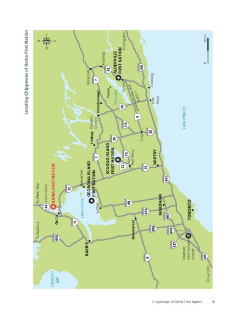
Locating Chippewas of Rama First Nation
                               E
                           N      S                                 To Kingston                            20 km
                               W
                                                          Hastings  ALDERVILLE  FIRST NATION               0


                                                            45               401
                                                   Norwood  7       Fenella      Cobourg


                                                        Peterborough  Keene  Rice Lake  28  NORTHUMBERLAND  ROAD 9  Port  Hope


                                                    Fowler’s  Corners  115  9                    Lake Ontario


                                                    Lindsay    35            Kirby  35


                                                       7    SCUGOG ISLAND  FIRST NATION  22  7A  Port Perry  12  WHITBY  Figure description and reference map differ; this map is based on reference map and msifn_02 Road into Scugog Island is Durham Regional Road 7 (not 22), according to multiple sources


                          To North Bay  RAMA ROAD  RAMA FIRST NATION  12  Beaverton  GEORGINA ISLAND  FIRST NATION  401  Highway 28 north of Port Hope is a county road, not a King’s Highway


                              44                Lake Simcoe  Sutton   48       404    MARKHAM       TORONTO

                                   Orillia  11                                           407
                          To Sudbury  400                               Newmarket  400     409


                                                  BARRIE                                    427  Pearson  International


                                                                               9                     Airport  401


                                 Georgian  Bay                                                               To London  OGEMAWAHJ COMMUNITY BOOKS  otccb_crfn_f02  Michael Borop  3rd pass


                                                                                 Chippewas of Rama First Nation  9     Figure Number  Creative  Pass  Approved  Not Approved


          ogemawahj_community_book5.indd   9                                                                 2019-03-14   8:11 AM