
Page 11 - Beausoleil First Nation
P. 11
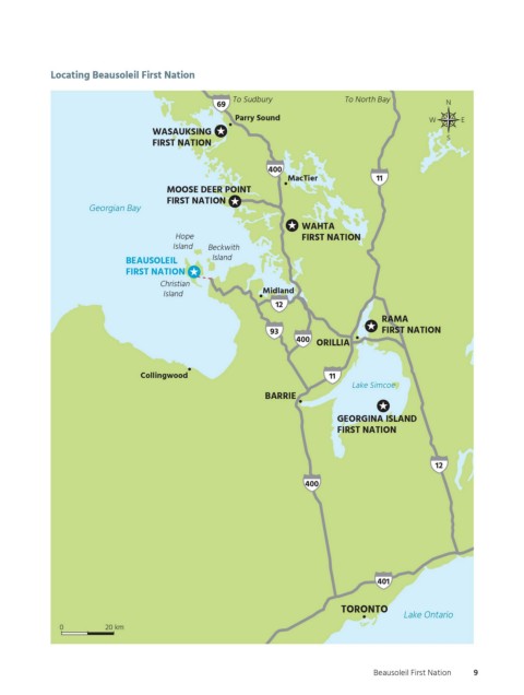
Locating Beausoleil First Nation

                                                          To Sudbury              To North Bay
                                                      69                                                N
                                                          Parry Sound                               W      E
                                         WASAUKSING
                                                                                                        S
                                         FIRST NATION

                                                                  400
                                                                      MacTier            11
                                            MOOSE DEER POINT
                                            FIRST NATION
                           Georgian Bay
                                                                         WAHTA
                                             Hope                        FIRST NATION
                                             Island  Beckwith
                                                     Island
                                   BEAUSOLEIL
                                   FIRST NATION
                                          Christian
                                                                Midland
                                           Island
                                                                   12
                                                                                          RAMA
                                                                  93                      FIRST NATION
                                                                        400
                                                                            ORILLIA


                                      Collingwood                              11
                                                                                    Lake Simcoe
                                                                 BARRIE

                                                                                 GEORGINA ISLAND
                                                                                 FIRST NATION


                                                                                                      12

                                                                          400


                                                                                         401


                                                                                 TORONTO
                                                                                               Lake Ontario
                    0         20 km


                                              Reference map shows Hwy. 69 south of Parry Sound, but that is actually Hwy. 400; Hwy. 69 is north of Parry Sound
        OGEMAWAHJ COMMUNITY BOOKS                                                       Beausoleil First Nation  9
        Figure Number  otccb_bfn_f02
        Creative      Michael Borop
          ogemawahj_community_book2.indd   9
        Pass          2nd pass                                                                              2019-02-27   10:33 AM
        Approved
        Not Approved